Showing posts with label google api. Show all posts

Monday, June 8, 2009

World Database on Marine Protected Areas new website

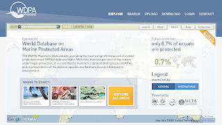
The UNEP-World Conservation Monitoring Centre (UNEP-WCMC) today unveiled  The World Database on Marine Protected Areas - a site designed to provide the most comprehensive set of Marine Protected Areas (MPAs) available.


"With less than one percent of the oceans under legal protection, i
t is essential to maintain a dataset that focuses on MPAs and representation of the diverse species and habitats found in the marine environment." is read on the website.

Vizzuality has developed the User Interface and general design of the website, including the logo. Working together with UNEP-WCMC, and specially Craig Mills, we have developed innovative solutions to display this huge amount of data in a hopefully engaging website to invite people explore our oceans. 

But enough of "official words", here at biodivertido we would like to explain what are the technologies behind it and how things work under the hood. 
Technologies:

The website is a mix between HTML and Flash. The Flash application in the front has been developed using the Flex framework plus some Flash little things. On the ser
ver s
ide there is ASP.NET and WebORB to do AMF remoting. 

GIS:
The GIS engine behind the scenes is ESRI ArcGIS Server. WCMC pr
epared the different tiles
 and caches for all layers. There is some places where we have used the new ArGIS Server REST API.

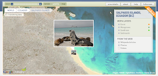
On the client side the whole project is very much based on the great Google Maps API for Flash. We want to thank Pamela Fox from Google for her great support of the community. There is several techniques that we have introduced while working on this project like:
  • Tile Mouse Over: To change the cursor when hovering over features on tiles.
  • WMS overlays: Dynamically changing the Tile Overlays based on zoom levels for cached and not cached tiles.
  • Panoramio and Wikipedia markers without proxies.
  • Encoded Polilynes for multipolygons with inner rings.
Database:
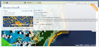
WCMC is using Microsoft SQL Server 2008 Spatial Database and we worked with them to generated Google Encoded Polylines out of the database. 
There are also some things coming from the ESRI spatial database and some stats where dones using it, but I think the general idea is to mo
ve everything to SQL Server.

Deployment:
The whole website is being served from an Amazon EC2 instance. The idea is also to make use of the Amazon Cloud Front CDN to distribute tiles and other static files, but for the moment everything is in EC2. 

We will probably post more specific details on different parts of this project in the next weeks, but we wanted to give you a broad overview of how the project works and the different technologies being used.

One more thing...
One great thing of working with UNEP-WCMC is that all the source code that we have developed is Open Source! We are still working on specific details on what license the source will get, but for those curious, starting from today you can checkout all source code from Vizzuality SVN repository. Please let us know if you find it interesting!

We are still under Beta phase of the project, so it might be that you find some bugs, please report them!.

Thanks again to UNEP-WCMC to let us work on this great project and look forward to make it better!

Saturday, June 6, 2009

Using Google Spreadsheets with Google Maps for Flash

I have recently been working on a little project that had a very simple purpose: Put in a map around 200 markers about where to find dog waste bags disposals in a town. This might have little intersection with biodiversity, but I think some of the ideas might be useful for other people.

The idea was to create a simple map/widget that could be managed by a non technical person and did not require setting up databases and hosting services. The kind of project you want to set up and forget more or less about it.

Well, the simplest thing to manage the location of the disposal is something like and spreadsheet and the internet version for that is Google Spreadsheets. I started thinking on using the Spreadsheet mapper, but it has far too much options, and we did not really need to share a KML file. So I thought creating something simpler. Just my required columns on the document and connect from Google Maps for Flash. So we wo
uld be able to just distribute the Flash SWF file and it will take 
care of connecting to Google Spreasheets, download the data and display it on the map.

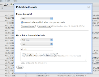
Sounds very easy no? Just publish the spreadsheet, setting automatically republish on changes, select the CSV format, and you get a perfect API to your data. Look at ours for example.
Then on the Flex app is as simple as parsing a CSV and dynamically create the needed markers.

The only problem is... Google does not like crossdomain.xml f

Therefore we were gonna have to create a proxy server to bypass the security restrictions, but we really did not like the idea of havi
ng to set up one just for this small thing and maintaining it. 

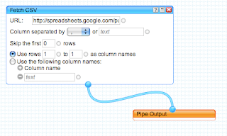
So I decided to take a look at Yahoo Pipes to bypass the crossdomain issue. You just need to create a simple Pipe that consumes the CSV from spreadhseets and output it as JSON. Yahoo pipes has an open crossdomain file, so no problems. Here is my pipe for example. Very simple and effective.

You can see the final result in here. And of course you can always grab the code from Vizzuality Google Code repository. 

The project had to deal also with transforming UTMs into Latitude/Longitudes and some other issues, but I think this overview is enough. The source code is so simple that I dont think its needs more explanations.

We would like to start using the Google Data API much more in the future, specially the shiny new Google Maps Data API, but I think this makes for a very simple solutions for lot of small projects like this one.

And finally, Google, please start setting up crossdomain files on your APIs, or at least, explain us why you dont do so... the actual situation is very frustrating.

Tuesday, June 17, 2008

Displaying Shapefiles in Google Maps for Flash (or any other AS3 mapping engine)

Recently I have been exploring different ways to let the user upload Shapefiles to a flex application and display it on Google Maps for flash or Umap. I am working on this for BiodiversityAtlas where users will be able to upload species distributions in SHP.

There are two easy options you can try:

1) Load the Shapefile natively in Flex using vanrijkom classes. Read the geometries and create overlays for the mapping api.
2) Process them in PHP using the ShapeFile.inc.php class developed by Juan Carlos Ulloa, send them, using AMFPHP,  as AS3 objects using similar to the mapping API and overlay.

I have tried both ways now. You can check the code of the first try and a demo at:

http://biodiversityatlas.com.s3.amazonaws.com/shps/shapeFileReader.html

I am still not sure which way I am gonna take for BiodiversityAtlas as both look fine to me. I probably will use the PHP way as in any case, if the user has to upload the file to the server then I can process i there anyway and I might store them directly on PostGIS even before displaying... so that looks my router.

But in any case is great to see I can go both ways and that both are surprising fast.

If anybody is interested on the PHP example please let me know. 

Wednesday, June 11, 2008

Taxonomic Browser in Flex

Last week I was playing with the Iphone and I loved its interface. While working for biodiversityatlas.com I wanted to implement some of the UI ideas for the taxonomic browser I am constructing.

The current component lacks of design, effects and a little bit of control on performance, but in general I am satisfied with it so I wanted to publish it here.

The images you see are coming from Google Images. So for every taxon it is displayed a request is sent to Google Api to look for the first image. Curiously we discovered that the results change depending in what country you are. Of course the images are not always correct but it gives a nicer way to help you navigate through higher ranks. For people like me that dont know much about the taxonomic tree it helps to find a Pinus at least!

I havent implemented much functionality when viewing a taxon detail, but this is because BiodiversityAtlas is about distributions, not so much about what data you have available for a taxon, like in the Iphone UI.

In any case this the taxonomic browser I am implementing now in BiodiversityAtlas. So please, if you like it give me some feedback :)